


Located in northern San Diego County, the City of San Marcos is home to approximately 94,000 residents. The City’s GIS program supports a wide range of municipal services—including planning, development services, public works, fire, finance, parks & recreation, stormwater, community economic development and the city clerk. Over the past two decades, the City had developed more than 100 different GIS data layers and maps to support daily operations and long-term planning.
However, its GIS environment had been running on on-premises infrastructure for over a decade, placing increasing strain on internal resources as demand for GIS capabilities continued to grow.
Challenge
As GIS usage expanded across departments, the City’s existing on-premises system struggled to keep pace. The environment faced:
- Limited scalability to support growing data and user needs
- Increasing maintenance demands on internal IT staff
- Performance and reliability issues
At the same time, the City needed to maintain uninterrupted access to mission-critical systems, including integrations with tools like Lucity for asset and work order management. Any transition would need to be seamless, with no disruption to operations.
Technical Solution
At the same time, the City needed to maintain uninterrupted access to mission-critical systems, including integrations with tools like Lucity for asset and work order management. Any transition would need to be seamless, with no disruption to operations.
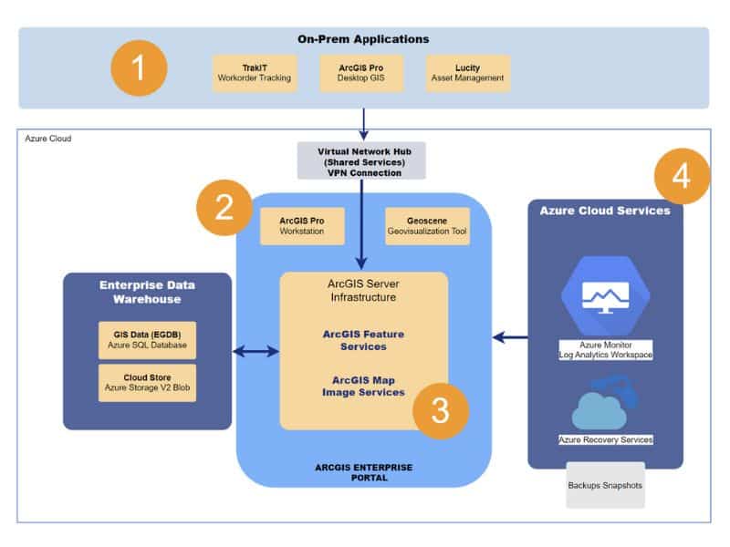
Cloud Architecture & Deployment
- Designed a multi-machine ArcGIS Enterprise deployment to support performance and future growth
- Built a cloud-native architecture spanning network, storage, database, and application layers
- Connected Azure infrastructure with the City’s on-premises network for seamless integration
Automated Deployment
- Leveraged Azure Bicep and Azure DevOps Pipelines to automate infrastructure deployment
- Used Esri PowerShell DSC to automate ArcGIS Enterprise installation and configuration
- Executed a fully scripted rollout to ensure consistency and minimize risk
Modernized Data & Applications
- Streamlined GIS database structures, reducing redundancy and improving data management
- Migrated to a managed cloud database with automated backups every 12 hours
- Transitioned from ArcMap to ArcGIS Pro, enabling more advanced and flexible workflows
Security & Reliability
- Implemented cloud-native security tools for continuous monitoring and threat detection
- Enabled automatic system updates to maintain performance and uptime
- Introduced redundant storage and backup systems to protect critical data
Software / Technology
- ArcGIS Enterprise (Server, Portal, Data Store)
- ArcGIS Pro
- ArcGIS Online
- ArcGIS Notebook Server advanced
- ArcGIS PowerShell Desired State Configuration
- Microsoft Azure
- Azure Bicep
- Azure Pipelines
- Azure Monitor
- Azure Backup (Recovery Services vaults)
- Azure Update Manager
- Azure SQL Database
- Azure Blob Storage
- Azure Application Gateway v2
Results
The City successfully migrated its GIS environment to the cloud with no data loss, no service interruptions, and no disruption to mission-critical systems.
Key outcomes include:
- Improved performance and reliability for GIS applications and services
- Reduced infrastructure burden by retiring two on-premises servers
- Scalable environment that grows with City needs
- Enhanced data access and editing speeds for staff
- Stronger security and backup capabilities
By moving to the cloud, the City now benefits from a stable, high-performing GIS environment that supports both current operations and future innovation. Staff can spend less time managing infrastructure and more time delivering value to the community.
Looking Ahead
The City and Quartic continue to collaborate on future enhancements, including migrating data editing to hosted data store items. The new foundation gives the City with the ability to evolve its GIS program with greater flexibility and confidence.
“I was 100% confident in Quartic’s ability to deliver a fully functional, secure, and integrated Azure cloud migration product.”
— GIS Program Manager