


Located on the southern coast of San Francisco Bay, Santa Clara County is home to Silicon Valley and is the sixth most populous county in California. The Santa Clara Valley Transportation Authority (VTA) is an independent special district that both operates the county’s public transit system—providing bus, light rail, and paratransit services—and serves as the Congestion Management Agency (CMA), overseeing transportation planning and investment to keep the region moving.
A Fragmented and Aging GIS Environment
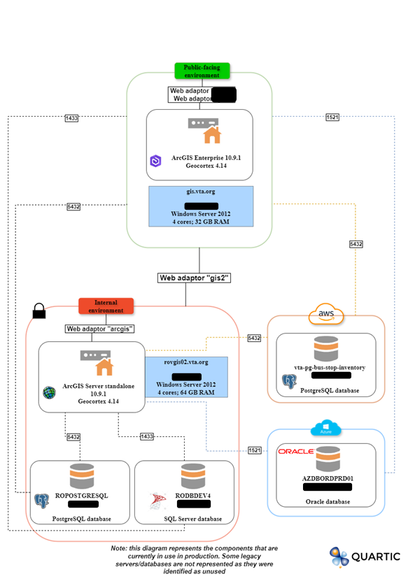
VTA was facing a complex, aging GIS environment affected by performance issues, fragmented data, and a growing maintenance burden. Over the years, VTA’s GIS environment had grown in multiple, uncoordinated directions. There were several ArcGIS servers and databases (SQL, Oracle, PostgreSQL) and aging on-premises infrastructure. This patchworked system was difficult to maintain, slow to load, challenging to scale-up, and prone to outages.
All the data was spread out in multiple systems; the environment was unstable and difficult to troubleshoot.
Chao Liu, Senior Transportation Planner at VTA
Moving Beyond Legacy Platforms
Beyond general maintenance and performance challenges, VTA was also concerned with its aging Geocortex platform. Geocortex Essentials and Geocortex Viewer for HTML5 are built on Esri’s now-retired ArcGIS 3.X JavaScript API. With future updates and long-term support coming to an end, VTA knew it needed to upgrade to Geocortex’s successor, VertiGIS. Moving to VertiGIS would allow VTA’s staff to more easily customize application interfaces and create tailored workflows without requiring coding knowledge.
Cloud Migration and Platform Consolidation
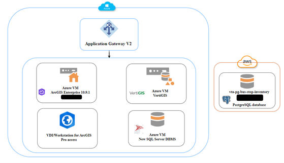
VTA enlisted Esri partner Quartic to migrate its entire GIS infrastructure to Microsoft Azure’s cloud environment. This transition also included consolidating VTA’s GIS architecture and making the move from Geocortex to VertiGIS.
In only six months, Quartic designed and delivered the full migration, from initial system assessment to final go-live. While there were a few brief periods when VTA staff were asked to pause editing, there was no downtime for end users. All maps and apps remained online and available to users throughout the process.
Migration Scope and Implementation
The migration process included:
- A full review and inventory of all data, web services, workflows, and applications
- Transitioning from Geocortex 4.14 to VertiGIS Studio Web 5.31.0
- Designing a future-ready architecture with improved reliability and scalability
- Migrating all systems to Microsoft Azure
- Consolidating multiple databases into a streamlined, centralized environment
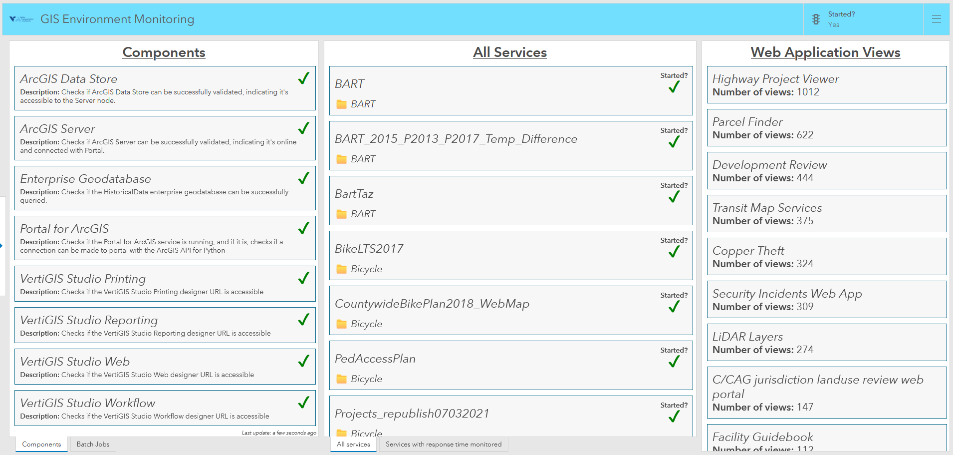
- Implementing a custom monitoring and alerting system
- Providing detailed documentation and knowledge-transfer sessions
“Quartic did the migration from start to finish,” says Liu. “We’d have a discussion, and they would make it happen.”
Results: Improved Performance, Stability, and Scalability
Since its migration, VTA has experienced zero outages, a dramatic improvement over its legacy setup, which suffered from recurring service interruptions. Performance has also improved significantly, with faster load times and quicker system response.
End users aren’t complaining about drawing times anymore! Everything is faster and easier to manage. Now all the data is in one place, and we have a single point of access.
Chao Liu, Senior Transportation Planner at VTA
The new, simplified architecture is easier to understand and maintain. With Microsoft Azure, server capacity can be adjusted as needed. Security is also enhanced, with best-practice configurations and Azure security protocols implemented across the environment.
VertiGIS in Action at VTA
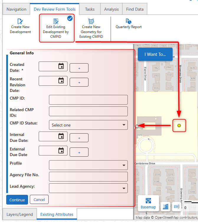
Using its new mapping application powered by VertiGIS, VTA can create new development records, update attributes and geometry for existing developments, and generate quarterly reports using custom tools designed to mirror previously established workflows. These tools ensure updates are applied consistently across datasets, improving data reliability and reducing manual effort.
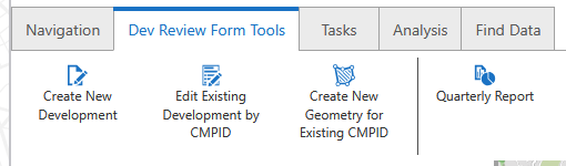
One example is the Edit Existing Development tool. When VTA’s GIS staff are notified of an attribute change, they can use this tool to retrieve current values, make updates through a form-based interface, and submit changes that automatically propagate across related datasets, saving time and ensuring data consistency across services.
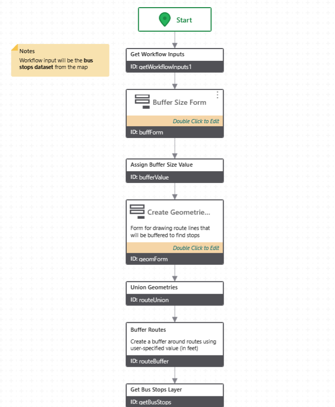
Another tool built with VertiGIS Studio Workflow supports temporary bus line rerouting by automatically generating reroute notices for impacted bus stops. For each affected stop, the tool produces notifications that clearly highlights affected routes, stops, time, and the reasons, streamlining what was previously a time-intensive, repetitive process.
Results: A High-Performing GIS Environment
By consolidating its GIS infrastructure, modernizing its applications, and moving to the cloud, VTA now has a reliable, high-performing GIS environment that supports both current operational needs and future growth. The modernized system empowers staff with faster tools, consistent data, and practical workflows, allowing the agency to focus less on system maintenance and more on delivering reliable transportation services to the public.
VTA’s new environment is stable, faster, and future ready. This project is a testament to our ability to take a complex, disjointed on-prem legacy environment, streamline it in the cloud, and deliver with zero loss or issues.
Jack Charde, GIS developer at Quartic

