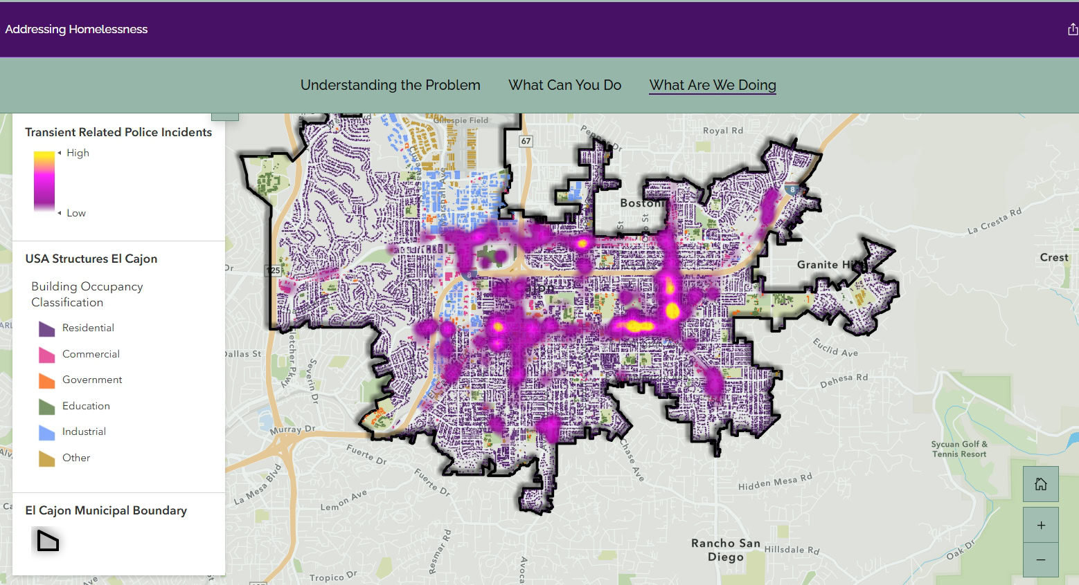
Public Safety

Supporting actionable, trustworthy data for rapid response

Public safety agencies operate in high-stakes environments where every second counts. Tools should be simple, reliable, and trusted in the moment.

Quartic partners with fire, police, sheriffs, and emergency management organizations to deliver mission-critical GIS solutions that are intuitive to use, resilient under pressure, and built for real-world operations.

Solving GIS Challenges for Public Safety

Public safety agencies rely GIS to support dispatch, field response, mutual aid coordination, and planning. Systems must be easy to use, dependable, and aligned with how teams actually operate. When GIS is complex, fragmented, or unreliable, staff revert to manual processes, and situational awareness suffers.

Below are common GIS challenges in public safety and how partnering with Quartic creates measurable improvement.

Problem: Unreliable or fragmented operational data

Public safety decisions rely on accurate addresses, response zones, critical facilities, and incident data. When GIS data is outdated, inconsistent, or spread across systems, responders and command staff lose trust– especially during time-critical incidents. When trust breaks down, teams often revert to paper maps and manual workarounds, slowing response.

OUR SOLUTION

Our Solution: Establish trusted, authoritative data

  • Standardize and validate critical datasets
  • Apply modern Esri data models and best practices
  • Keep data accurate and up to date across systems
  • Enable real-time decisions in the field and at command

Learn more about our GIS Data Services.

Problem: Limited real-time situational awareness

During incidents, information often lives in separate systems — CAD, AVL, RMS, field reports, and spreadsheets. Without integration, leaders lack a clear, unified view of units, hazards, and active events. Tools that are too complex and hard to navigate may be abandoned in high-pressure situations.

OUR SOLUTION

Our Solution: Create a simple, real-time operating picture

  • Integrate CAD, RMS, AVL, and other operational systems into a single view
  • Use dashboards, web apps, and mobile tools designed for clarity and speed
  • Deliver critical information exactly where and when it’s needed
  • Support situational awareness across teams

Learn more about our Industry Solutions.

Problem: Disconnected workflows between dispatch, field, and command

When workflows are cumbersome, staff may bypass systems entirely. Manual updates and verbal communication introduce errors and slow coordination.

OUR SOLUTION

Our Solution: Gain connected GIS workflows

  • Connect field data collection, dispatch systems, and command dashboards
  • Ensure information flows quickly between responders and leadership
  • Design workflows that are simple and effective in real-world conditions
  • Reduce friction and improve adoption across teams

Learn more about our GIS Planning & Consulting Services.

Problem: Aging GIS platforms that limit operational use

Legacy GIS environments often struggle to support real-time operations, system integration, and secure access. Slow performance and complex interfaces reduce usability—making it harder for teams to rely on GIS during time-critical incidents.

OUR SOLUTION

Our Solution: Modernize and sustain your GIS program

  • Build scalable, high-performing GIS architecture
  • Improve usability across the organization
  • Access flexible GIS support without long-term commitment
  • Accelerate high-priority GIS projects

Learn more about our GIS Enterprise Services and multi-level GIS Support Services.

success stories for Public Safety

See How Organizations Are Putting GIS to Work

Real projects, real results. Here's how teams like yours are solving complex challenges with smarter location intelligence.

  • Istock 1679925803

    County of San Diego Utilizes GIS During Storm

    The County’s Emergency Operations Center (EOC) used its mapping software and technology to respond to Tropical Storm Hillary this January. While the storm significantly impacted public and private property and led to power outages and network issues for several days, the EOC effectively provided maps to support the response efforts. The maps facilitated coordination between…

  • Istock 1192706887

    City of El Cajon Tracks Hazardous Material Placards

    GIS can be used in many ways to improve the operations of cities and local governments. The City of El Cajon uses GIS to discover, maintain, and visualize its NFPA 704 Warning Placard data. When large amounts of hazardous materials are stored and used at a business, warning placards are required. These placards act as an…

Why Partner With Us?

We bring technology, people, and processes together to create lasting value.

  • Proven GIS expertise in public safety

    100% U.S. based and certified staff!

    Experience supporting law enforcement and emergency management agencies with mission-critical GIS systems

  • Tailored solutions for real-world challenges

    We understand that GIS must work in fast, high-pressure environments. Our solutions are designed to be intuitive, reliable, and accessible—supporting dispatch, field response, command staff, IT, and regional coordination. We integrate GIS with CAD/RMS systems, manage authoritative data layers, and ensure information is accurate and usable when it matters most.

  • Reliable, practical, scalable implementations

    We believe your GIS needs to work for you. We consider your resources, budget, and vision. The result: a realistic solution that delivers. 

  • A true partnership mindset

    Your team is supported every step of the way.

Let's Build Something Better Together

Your agency deserves GIS systems that work as hard as your team does. Connect with us to explore how our solutions can reduce friction and restore confidence in your platform.

company testimonials

Don't just take our word for it...

Real results from real clients across industries who've modernized their GIS with our support.

The collaboration between Quartic and Esri has been great and made the project successful.

Happy Client

My favorite part of this project has been working with the Quartic team, who are always upbeat, professional, innovative, positive, and smart. The outcome of this project was just what we wanted, and it benefitted us on many levels.

GIS Analyst
City of El Cajon

The support I received from Quartic was very positive. The Quartic team member was supportive, knowledgeable, and efficient throughout the update of our Esri ArcGIS enterprise environment to version 11.5. The update went smoothly and without any issues, which I attribute to his expertise and preparation. I was very pleased with the level of support provided and how seamless the entire process was.

Sr. GIS Analyst
Water District Client

We trust Quartic always to keep our best interests at heart.

Happy Client

Quartic’s deep knowledge of GIS and ability to solve problems has transformed our GIS system.

Happy Client

Since SanGIS went live with the new ArcGIS Pro editing environment, there have been no platform or system issues, and Parcel Fabric has been running smoothly.

Program Manager
SanGIS

Your GIS Shouldn't Hold You Back

Legacy systems and technical debt don’t have to be your reality. We’ll build a reliable platform that keeps pace with growing demands.